
About
Dexter Reservoir
This approximately 1,000-acre reservoir sits on the Middle Fork Willamette River, about 20 minutes southeast of Eugene in Lane County near the towns of Lowell and Dexter. Created in 1954 by the U.S. Army Corps of Engineers when they completed the 117-foot Dexter Dam, the reservoir serves as a reregulating dam that captures cold water discharged from Lookout Point Dam during power generation. Together, the two reservoirs generate up to 15,000 kilowatts of hydroelectric power and prevent flood damage downstream. Unlike other area reservoirs, Dexter maintains full water levels year-round (varying only a few feet), making it accessible for paddling in all seasons. The University of Oregon Rowing Team has practiced continuously on the reservoir since 1967. Two state recreation sites provide access: Dexter State Recreation Site (southwest side, right off Highway 58) and Lowell State Recreation Site (north shore, away from highway noise).
Water Conditions & Skill Level Beginner-friendly. Crystal-clear water with typically calm, placid conditions – mornings often calm as glass. The reservoir’s stable year-round water levels make it ideal for beginners, families, and first-timers. Popular for rowing regattas, which tells you the water is typically quite flat. Motorized boats permitted including sailboats, water-skiers, and powerboats, so expect some boat traffic and wake, especially on summer weekends and during peak hours. Early morning or after peak summer season offers calmest paddling. Beware of obstructions beneath the surface – always wear a life jacket. Reservoir remains calm enough for crew practice and rowing races.
Access & Launch Two primary access points: Dexter State Recreation Site (southwest edge): Convenient location right off Highway 58. Two-lane launch ramp with courtesy dock provides easy boat access. Quieter than Lowell during busy times. Lowell State Recreation Site (north shore): Four-lane boat launch ramp, marina with rentable moorage, large courtesy dock. More amenities including swim beach. Located away from highway noise – better for families wanting shore-based activities. Both sites offer good access. The historic Lowell Covered Bridge (dating to 1947, widest covered bridge in Oregon) sits with just 2-foot clearance above the reservoir – paddlers can go under the bridge. Typical paddle routes: 2-mile round trip from Lowell to bridge, 3-mile round trip from Dexter to bridge, or continue under bridge toward Lookout Point Dam for up to 2 additional miles.
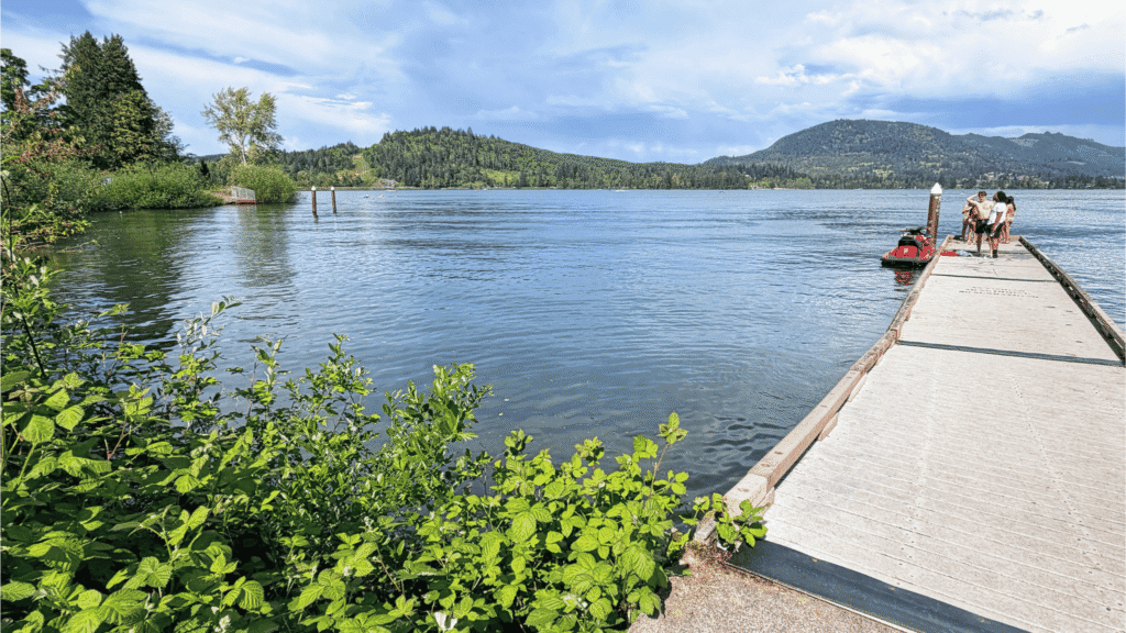
What You’ll See Views of pine-covered slopes and rolling, forested hills surrounding the reservoir. The old train trestle at Lowell visible from water. Historic Lowell Covered Bridge – placed on National Register of Historic Places in 1979. Abundant wildlife including bald eagles (frequently sighted), beavers. Feels like a mountain lake despite being only 20 miles from Eugene. Nearby Elijah Bristow State Park (847 acres) stretches 3 miles along south bank below Dexter Dam with 12 miles of trails through woods and meadows, wildlife viewing platform, equestrian staging areas. Excellent fishing for various species. Drag boat races hosted at Lowell each summer. Rowing regattas each spring hosted by Oregon Association of Rowers and University of Oregon (boathouses located at Lowell).
Best Times to Go Year-round paddling as weather permits – water levels maintained throughout the year unlike other area reservoirs that drain for winter storage. Early mornings best for calmest water (calm as glass). Visit early mornings or after peak summer season for quieter paddling with less boat traffic. Summer sees most activity including water-skiers, sailboats, powerboats, rowing practices. Weekdays quieter than weekends. Check for scheduled events – reservoir closed for specific boating events such as drag boat races and rowing regattas (closures posted in park and online advisories). Check for blue-green algae blooms before heading out, as the area is prone to them.
Amenities Dexter State Recreation Site: Day-use only (no camping). Two-lane boat ramp, courtesy dock. Picnic area with BBQ stands and fire rings overlooking lake. Popular 18-hole disc golf course winding through oaks and Douglas fir trees. Connecting trails to nearby Elijah Bristow State Park (3 miles west) following Middle Fork Willamette River. Life jacket loaner station near boat ramp with various sizes. QR codes throughout parking lot for purchasing day pass.
Lowell State Recreation Site: Day-use only (no camping). Four-lane boat launch ramp, marina with rentable moorage, large courtesy dock. Reservable picnic shelter overlooking lake. Wooded picnic area with tables. Children’s playground, basketball court, volleyball net. Large lawn area with picnic tables. Swim beach. Expansive grassy field sloping to water. Flush restrooms open year-round. Oregon Association of Rowers and University of Oregon boathouses.
Fees & Notes Oregon State Parks day-use fee required. Annual passes available. Oregon Waterway Access Permit required for paddleboards 10+ feet. CRITICAL: Blue-green algae blooms common April through September but can occur any time of year. Dexter Reservoir particularly vulnerable to harmful algal blooms. Always check Oregon Health Authority recreational advisories before visiting. If bloom present, avoid swallowing/inhaling water droplets and skin contact for humans and animals. Use common sense – if water doesn’t look right, choose another location. Fee waivers/adjustments not provided due to algae presence. Check water levels at U.S. Army Corps of Engineers website before visiting. Check Oregon State Marine Board’s Reported Obstructions and Alerts page for underwater hazards. Inspect and clean watercraft between uses to prevent spread of aquatic invasive species.
Map
Sorry, no records were found. Please adjust your search criteria and try again.
Sorry, unable to load the Maps API.